As most western travelers know, the state of Utah is fortunate to have many unique National Parks. One of those unique National Parks is Bryce Canyon.
Thank you for reading this post, don't forget to subscribe!
Bryce Canyon sits on the spectacular edge of the Paunsaugunt Plateau, a place where intricately carved towers and archways of stone shimmer in a dazzling array of color. Because the park is on a plateau it really isn’t a canyon but it is marvelous.
The Geography of Bryce Canyon National Park
Bryce Canyon’s rock is composed of layers of sediment deposits. Millions of years ago the area of Bryce Canyon was a lake. The sediment was deposited over these millions of years. Today, the Paria River has exposed the layers.
Geography changes. The region shifted about 15 million years ago resulting in a series of plateaus. The Paunsaugunt Plateau is quite large and the Paria River gradually eroded away the plateau’s edge to form beautiful Bryce Canyon.
Bryce Canyon National Park
Bryce Canyon took it’s name from an early pioneer to the region. Ebenezer Bryce. came over from Scotland, married a local girl then moved southwards in steps, building sawmills as he went. In the mid 1870s Bryce and his wife reached the Paria River, where they along with some of his relatives settled for a several years.

Bryce Canyon National Park was founded in 1924. The area was remote. European tourists to America didn’t venture there thus the first guest houses were built about the time the park was established.
The good part of this is that Bryce Canyon became an area of largely unspoiled beauty. The park is known for it’s enormous scientific value since plenty of historic information is trapped in its pinnacles & spires. It’s been determined that the rim recedes by about a foot every 50 years
The Hoodoos Of Bryce Canyon
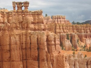
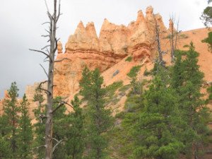
The rock scenery at Bryce Canyon is commonly referred to as “Hoodoos“. Hoodoos are tall skinny spires of rock that protrude from the bottom of basins and “broken” lands.
Because the rock was laid down in layers, the hardness tends to vary. When water runoff trickles across the rock, some parts erode quite fast whereas other parts hold firm.
This variation in erosion speed causes the formation of pinnacles, or “hoodoos” of stable rock. In some places the water seeps down through cracks & eats out holes beneath the surface. When the side rock erodes away, an archway is left behind.
It is only a matter of time before the arch of the rock collapses. This results in another colorful pillar.
Visiting Bryce Canyon National Park
Bryce Canyon is open all year round. Visiting Bryce Canyon National Park is a treat regardless of the season of the year. During the warmer months hiking is quite popular. Look up at some spectacular formations. Sunset Point & Inspiration Point are a must for any visitor. Summer months can cause temperatures in the bottom of the canyon to soar. It is very important to be prepared for the heat by packing plenty of water for your journey.
As mentioned above, the park is open all year. For those who love the winter outdoors it is possible to cross-country ski in several areas of the park. You can also go snowshoeing instead of hiking on some trails. In winter the roads are opened between snowfalls, allowing a different perspective of the park. Snow capped pinnacles stand out sharply against the background of white snow and dark green trees. In winter the roads are opened between snowfalls.
See these Trips Into History articles on the links below…
The Bering Land Bridge National Preserve
The Great Sand Dunes / A Colorado Adventure
Getting There
A visit to Bryce Canyon National Park can also be combined with visits to Utah’s Zion National park and south of that the beautiful Grand Canyon. Traveling from Bryce Canyon to the Grand Canyon will take you over the Glen Canyon Dam in Page, Arizona, another fun attraction to stop and tour.

From the South through Zion National Park: Take I-15 north to UT-9 (exit 16). Follow UT-9 east through Zion National Park to US-89. Travel north on US-89 to UT-12. Go east on UT-12 to UT-63. Take UT-63 south to Bryce Canyon National Park. The visitor center sits 1 mile inside the park boundary.
From the South through Zion National Park: Take I-15 north to UT-9 (exit 16). Follow UT-9 east through Zion National Park to US-89. Travel north on US-89 to UT-12. Go east on UT-12 to UT-63. Take UT-63 south to Bryce Canyon National Park. The visitor center sits 1 mile inside the park boundary.
(Article and photos copyright Trips Into History)
