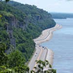
One of the best trips available to anyone wanting to explore our country’s history are the many scenic byways found east and west and everywhere in between. One of the most popular of these highways runs along the eastern bank of the Mississippi River and makes a great family trip back into history.
Thank you for reading this post, don't forget to subscribe!In southwestern Illinois, locals as well as tourists have a very unique trail to explore. For thirty-three scenic miles is The Meeting of the Great Rivers Scenic Route which was made an Illinois State Scenic Byway on June 8, 1998. There are no fees along the byway proper and ferries on the byway are free.

The Historic Mississippi
All through history, the Mississippi River impacted numerous lives: the Dakota, Chippewa, and Hopewell societies; early French voyagers; African-Americans looking for opportunity on the Underground Railroad; and a lot of people more. Through its beguiling stream towns and metropolitan urban communities, notable locales and social antiques, today’s Great River Road still connects communities, individuals, and history.
The Great Rivers Meet
This stretch where the Mississippi River meets the Missouri is an historic site. The Mississippi, a working waterway, is additionally an ecological fortune. Memorable eighteenth century waterway towns, islands, bars, focuses, and twists make excellent view underneath limestone feigns that are secured by timberlands reaching out over about 20,000 sections of land.
Following are just a few of the many attractions and historic sites along and near to the Meeting of the Great Rivers Scenic Route.

The National Great Rivers Museum
Opened in October 2003, this excellent and well laid out museum is committed to telling the story of everyday life on the Mighty Mississippi River and how it has molded our society, history, economy, biology and individuals. The National Great Rivers Museum has more than 20 interactive displays concentrating on the cycles of the waterway, nature, scow activity, water utilization and plenty more.
A plethora of history relating to life on the waterway and a complete explanation of why we need locks on the river for efficient transportation. The museum offers reasons why all should take an interest in the preservation of our country’s rivers. The National Great Rivers Museum is located at 2 Lock and Dam Way, Alton, Illinois.
Lewis & Clark Confluence Tower
The Lewis & Clark Confluence Tower is the gateway to the Meeting of the Great Rivers National Scenic Byway. The northern tower features a visitors center. When you’re at the visitors center you can plan your thirty-three mile journey down the scenic byway. The visitors center features videos and graphic displays that tell stories of history, wildlife and communities all along this historic and scenic path
The Lewis & Clark Confluence Tower is located in Hartford, Illinois. This is two miles from the Lewis & Clark State Historic Site. The Lewis & Clark Confluence Tower was built in commemoration of the historic expedition to the northwest and the Pacific. The tower which is 180 feet tall offers visitors three viewing areas at the 50, 100 and 150 foot levels. These connect the two towers that were built to represent Captains Meriwether Lewis and William Clark and the Mississippi and Missouri rivers. The location of the towers is at 435 Confluence Tower Dr., Hartford, Illinois.
Wood River Museum and Visitors Center
The Wood River Heritage Council has worked diligently to preserve the town’s history. The Wood River Museum and Visitors Center is the place to visit to learn all about area events such as the Wood River massacre of 1814, the Flood of 1915, Olde Towne. and the history of Standard Oil’s impact on the community. The museum is located at 40 W. Ferguson Avenue, Wood River, Illinois.
You may also enjoy the Trips Into History articles found on the links below…
A Drive on Wisconsin’s Lake Superior Scenic Byway
Michigan’s Copper Harbor Scenic Byway

Pere Marquette Cross
French explorer Louis Joliet and Jesuit priest Father Jacques Marquette led the first French expedition down the Mississippi River in June of 1673 in search of the Pacific Ocean.
Their expedition followed the Mississippi River south to the mouth of the Arkansas River. When reaching that point the Native Americans they encountered told them they were only about ten days away from the Gulf of Mexico. The expedition leaders decided to turn around for home lest they be captured by either the Indians or the Spaniards.
There were positive things that came from the expedition although finding the Pacific Ocean was not one of them. Marquette and Joliet were credited with establishing relations with the Native American tribes that they met along the way. What they learned of the area eventually led to the French taking possession of Louisiana.

Cut from a solid piece of dolomite, the Pere Marquette Cross is seven feet six inches high. It is located on a ledge of a bluff that overlooks the Illinois River. Two flights of dolomite stairs lead from the Sam Vadalabene Bike Trail to the cross. The Pere Marquette monument is located 4 1/2 miles east of the main Park entrance on the Great River Road.The location is 13122 Visitor Center Lane, Grafton, Illinois.
More Information
The north end of this scenic route is at the Pere Marquette State Park. The southern end of the route is at the confluence of the Mississippi and Missouri Rivers.
For more information about planning a trip along the Meeting of the Great Rivers Scenic Route, check out the websites listed below.
Meeting of the Great Rivers Visitors Guide
(Article copyright 2014 Trips Into History. Route map image courtesy of the Dept of Transportation, Great River Route Highway Photo and Lewis & Clark photo courtesy of the Federal Highway Dept. Great Rivers Highway photo north of Alton, Illinois courtesy Kbh3rd, CC 3.0 license.)

