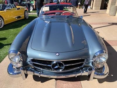
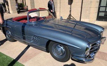
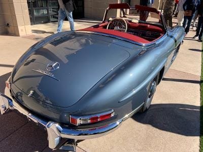
Here is the classic 1958 Mercedes-Benz 300 SL Roadster The very rare Roadster model came directly from the popular Mercedes 300 SL Gullwing which itself was derived from a 1953 Mercedes-Benz endurance race car.
Starting with the W194 Mercedes model (The W194 of 1952 was the first entirely new racing car built by Mercedes-Benz after the end of World War Two) came the 300SL Gullwing which was produced from 1954 to 1957. Then followed the 300SL Roadster from 1957 to 1963, those produced without the gullwing doors.
All of the these models, the Gullwing and 300SL Roadster, were hugely popular. People who could afford one, and wanted a powerful fast car that looked like a race car, had one. This included celebrities at the time such as Clark Gable and Yul BrennerIt and the well known architect Frank Lloyd Wright. The cars had great styling and looked fast. In addition to that they were very fast. The 300SL Roadster had a reported top speed of 163 MPH. That is a fast top speed today and certainly a very fast top speed for the 1950’s.
The Mercedes-Benz 300SL Roadster Styling
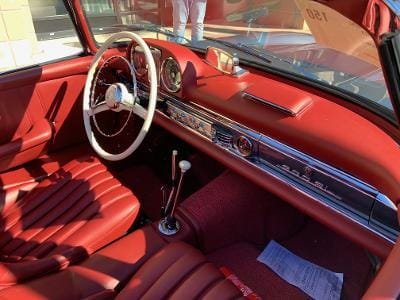
Depending on what model and what year you purchased your 300SL, you could get an aluminum hood, roof, and deck lid, and disc brakes. These were the types of features typically found on race cars of the time, not on production automobiles.
The Mercedes-Benz 300SL was based around a chromoly tubular space frame. Chromoly is a type of low alloy steel which is stronger and more durable than even carbon steel. In addition, it is resistant to oxidation and very light weight.The Mercedes 300SL was a pioneer in this type of light weight multi-tube chassis construction.
The styling of the 300SL Roadster goes back to the W194 which was an endurance type racer. While there are many similarities between the two, clearly the 300SL has a wider and more attractive grille with it’s three pointed star and the addition of chrome trim. To be sure, the 300SL was a very modern looking automobile.
Mercedes-Benz and Daimler Benz
What is Mercedes-Benz today was founded by Karl Benz and Gottlieb Daimler and was first called Daimler-Benz. The Mercedes-Benz name is a combination of two names: Mercedes Jellinek and Karl Benz. Emil Jellinek who later was known as Emil Jellinek-Mercedes was a wealthy automobile entrepreneur and was with Daimler (DMG) at one time placed on their board of directors because of his marketing knowledge. DMG went ahead in 1902 and filed a trademark for the name “Mercedes”. His daughter’s name was Mercedes Jellinek and Emil legally changed his name to include Mercedes. Jellinek who had a history in auto racing was a believer that racing success would lead to an automaker’s overall success.
Eventually Emil Jellinek convinced Daimler to develop a lightweight automobile with a powerful engine and a low center of gravity. Mercedes-Benz was formed in 1926 and was met with great success producing about 7,000 cars during its first year.
1958 Mercedes-Benz 300Sl Roadster Specifications
The 1958 300SL was built with a 3.0 liter straight six delivering 230 HP. The car used mechanical fuel injection which was a first for a production automobile. Mercedes used the mechanical fuel injection starting with the 1953 racing season. This engine was also shared with the 300 Sedan.
Zero to 60 rime averaged about 8.5 seconds which in 1958 was considered very quick and as previously mentioned the 300SL reportedly could reach a top speed of 163 MPH.
Transmission for the 1958 300SL is a four speed manual.
Brakes are servo-assisted drums.
Suspension is independent with coil springs along with a swing axle at the rear. This revised suspension system resulted in better handling and more comfort.
Dimensions include a 94.5 inch wheelbase, 178.0 inch overall length, 70.5 inch width, 51.2 inch height. Curb weight averaged 3,000 lbs.
1,858 Mercedes-Benz 300SL Roadsters were produced during the production run.
Related Auto Museum Online articles are on the links below..
1958 Mercedes-Benz 220S Ponton Sedan
Reference material used for this article includes..Mercedes-Benz Supercars : From 1901 To Today by Thomas Wirth..The Ultimate History of Mercedes-Benz by Trevor Legate..Mercedes-Benz The 1950’s by Bernd S. Koehling..Complete Book of Collectible Cars by the Editors of Consumer Guide.
The Mercedes-Benz 300SL Roadster is a Popular and Rare Collector Car
The Mercedes-Benz 300SL Roadster is one of the most iconic automobiles produced by this automaker. The model was derived from the endurance racing 300SL (W194) which relates to the first European auto racing after World War Two. It is also a very rare car since the models production from 1958 to 1963 totaled only 1,858 vehicles.
Today, many regard these models as legends and as the world’s original supercars. They are among top European collector cars and come with prices to match. Because of the relatively low production numbers and the steep prices that go with that, few of these come to the auction block.
Average selling price at auction for the Mercedes 300SL Roadster is about $1.2 million with the highest price approaching $2.0 million.
(Article and photos copyright Auto Museum Online)